
Since I have been coming to the Jungfrau Region for the past few years, the hike that I have found the most tantalizing is the hike to the summit of the Schwarzhorn. Schwarzhorn is listed at 2928m in elevation which would make it the highest summit that I have ever reached.
On the Grindelwald hiking map there are many trails, but the only one that seems to expressly be for the purpose of reaching a summit is the route to the Schwarzhorn. In fact, there are two routes shown. One is clearly out of my skillset and requires rope and rock climbing skills. This is called the Klettersteig route. The other teases with the term “Alpine Route” on the Grindelwald map key (route with the blue 18). I’ve come across one of these before with the Bäregg to Schreckhornhütte route. They are more difficult, go into higher elevations and sometimes require a little climbing (and overcoming some fear of heights).
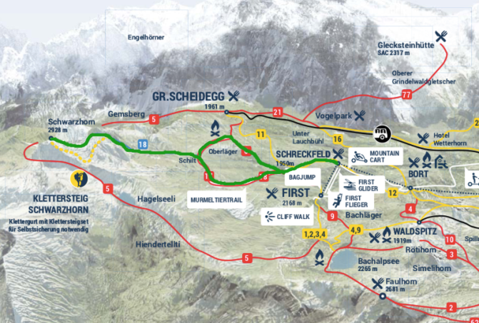
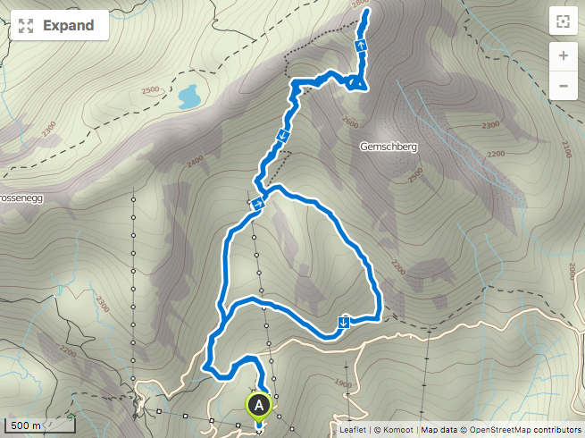
But when I read that the Schwarzhorn summit can be done without special equipment, I knew that for my 2018 summer holiday in Switzerland, this was absolutely THE hike I wanted to accomplish more than any other. I planned a route on my favorite hiking app, Komoot, and above I have highlighted the route on the Grindelwald hiking map.
I decided to start from the Schreckfeld cable car station. It is about 50 euros round trip from Grindelwald so don’t expect these hikes to come cheap.

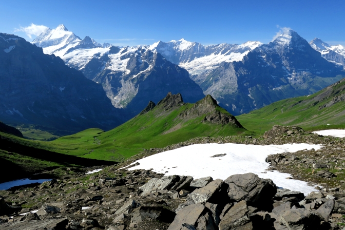
I was a bit nervous about the weather forecast so I decided to get to the Grindelwald cable car station at 8:00 when they opened up. This turned out to be a blessing because I was the only person on the way up. There were a couple sections which tested my fear of heights but after a grueling climb, I couldn’t let them stop me. I will point them out later in the photos. They were not difficult, but fortunately I was able to keep vertigo from kicking in. In the end, other than some stubborn light grey clouds floating around the summit, the entire hike was in complete sunshine. I stood at the summit completely by myself enjoying the most spectacular view I have ever seen at the top of a mountain.
The Route
- Starting Point: Schreckfeld Cable Car Station
- Ending Point: Schreckfeld Cable Car Station
- Distance: 12.1 km
- Time: 3:05
- Eating Place: Hotel Restaurant Schreckfeld

Tips
- Have good quality hiking shoes with a solid grip. There are a lot of loose stones on the alpine route. A hiking shoe with worn out treads or anything other than a hiking shoe could slip a lot.
- Download an app called MeteoSwiss. It is a pretty cool app for precipitation forecast.
- My Belgian SIM card does not get data in Switzerland but I have a UK SIM card which does. If you find yourself surprised that your SIM does not get data, the Komoot app will be handy because you can download your route and map for offline use. Then not having data doesn’t matter.
- Carry a first aid kit on this hike. The stones at the top are razor sharp. If you fall or slip and try to grab a ledge, it can slice right thru your skin. Don’t let this deter you from doing the hike though.
- Always….ALWAYS check the weather forecast. The summit is entirely exposed and very narrow with sharp drops on most sides. Be smart.
- I have never hiked at these altitudes so be wary of altitude sickness. It was a mixed blessing, the faster I hiked, the more I would feel a twinge of nausea. Better to do the hike methodically with short but frequent rests. This completely did the trick.
Now for the pictures….
Starting at Schreckfeld.

The Schwarzhorn is the peak in the distance.

Every view becomes more impressive as you head up the trail.

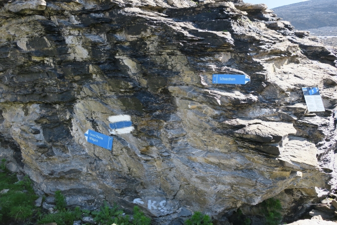
When you reach this sign, follow the blue trail towards the alpine route.

After a while the real fun begins.

As you start climbing, take a look back.
Follow the blue and white markers. When you reach this rock, go right!
You will start zig zagging up thru the rocks. Stay on the trail. You will encounter glaciers which you can carefully cross. A path is noticeable. The worst thing to fear is a bit of snow in the boot. No crevices here.

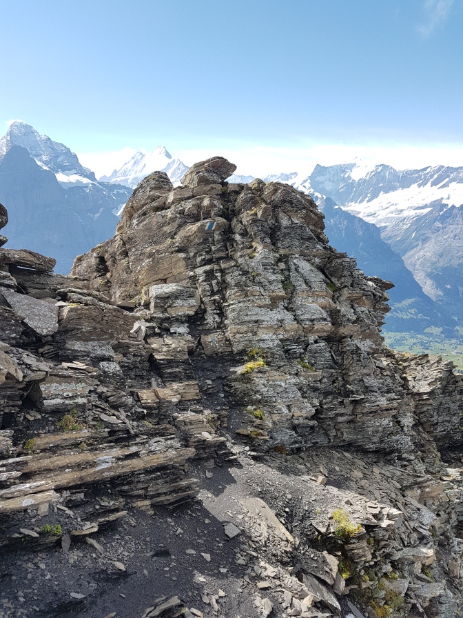
At the higher elevations, the rocks are very sharp and stick out like razor blades from the earth.

As you approach the summit, the two sections which I would consider the most hair-raising for someone afraid of heights (like myself). One is a small section you must climb down (and back up) and the other is a tight path hugging sharp razor rocks and overlooking a steep drop.

Finally at the top, don’t be fooled by the cairns. The real summit is still a short distance further. The views are incredible.


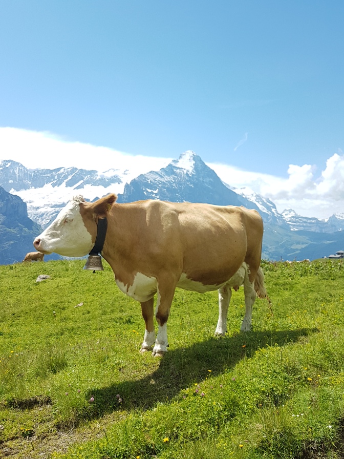
Now it just repeating your footsteps until you get to the cool Stegosaurus-like ridge. Then you will do the loop part of the trail. Along the way, you get to meet the local cow population.

Then it is back to the Schreckfeld cable car station for a relaxing ride back down to Grindelwald.
Final Thoughts
It was a pretty proud day for me. I doubt I will ever be into serious mountaineering given my fear of heights. I can’t imagine I will find many peaks like this which are just on the edge of what my fear of heights can stand and where you can achieve it with just a good pair of hiking boots and a well-stocked backpack.


Wow! What a spectacular moment 🌷
LikeLiked by 1 person
Thank you Ellie, that means a lot to me 🙂
LikeLiked by 1 person
😊
LikeLike
I loved reading this! Coming from Colorado people are always surprised when I say I’m afraid of heights. While I enjoy the beautiful views I’m overall a huge pansy! Hopefully someday I’ll be able to do something like this! Very cool.
LikeLike
Thank you and much appreciation for reading. I am sure we rank close on the same pansy scale. 🙂 I also hope you find your Schwarzhorn. In this case, it was the fear of failure that won over. haha
LikeLike
Hi 🙂 Absolutely Wonderful!! Is this possible at all for a solo beginner?
LikeLiked by 1 person
Hello! If you are fit, it will be no problem at all.
LikeLike
And thank you for the kind words 😊
LikeLike
Hey thanks for the Trip Advisor publicity! It looks like you are taking the more difficult route with the climbing involved? Anyway, good luck!
LikeLike