
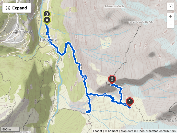
The Alpine mountain huts, Rottalhütte and Silberhornhütte, in the Jungfrau Region have been on my radar for a couple years. They both appear tantalizingly in striking distance from my homebase in Stechelberg and both branch off from the same initial trail.
Neither of them are particularly far, about 7km in distance from Stechelberg, but they are high up in the mountains which makes those 7km feel like a lot more. Both of them would involve an elevation difference that would exceed my personal best. This means either of them would be a long, slow ascent and a good 10-12 hours should be expected for a roundtrip.
| Hut | Elevation change from Stechelberg | Elevation |
| Rottalhütte | ~1810m | 2755m |
| Silberhornhütte | ~1700m | 2663m |
Anytime you are doing hikes in Switzerland, the weather forecast becomes your constant companion. I recommend downloading the MeteoSwiss app to your phone. The only advice I can really give is that the weather is unpredictable and the good news is that in all my time in the Jungfrau Region, only once did a bad forecast completely come true during the day. The mountains here have a unique way of holding off the worst of the weather until the evening. So generally speaking, if you start your hikes before 8am, there is a good chance you will make it back before any forecasted and prolonged rain really breaks thru. That is not to say you won’t get hit with a spurt here and there, but during the day they are usually short and not too intense.

The forecast for the week of July 19, 2020 showed a lot of rain and thunderstorms from Tuesday onwards, but Monday was perfect. I decided to start the week with Rottalhütte to give myself the best opportunity to do the potentially most difficult hike without worrying about the weather. So at about 6:30am, I set out with my well-stocked backpack to meet my fate.
Backpack Contents
| 2x 750ml water bottles with isotonic energy powder |
| 2x 750ml bottles of Rivella |
| 2x bananas |
| 2x bags of assorted nuts and dried cranberries |
| 3x energy bars |
| First aid kit |
| 1x can of beer for the photo |
| Phone battery charger + cable |
| Sunblock |
| Windbreaker |
Rottalhütte is not intended for the casual hiker and therefore, you don’t see the typical yellow signs pointing the way to it. A wooden sign indicates the trailhead, but after that you will only see the occasional reference painted on rocks. In fact, I noticed on the way up that I never saw any signs for the Silberhornhütte. It doesn’t even appear on my regional trail map, but the Komoot App does show it. So having this gps tracking app on your phone is quite handy for this hike.

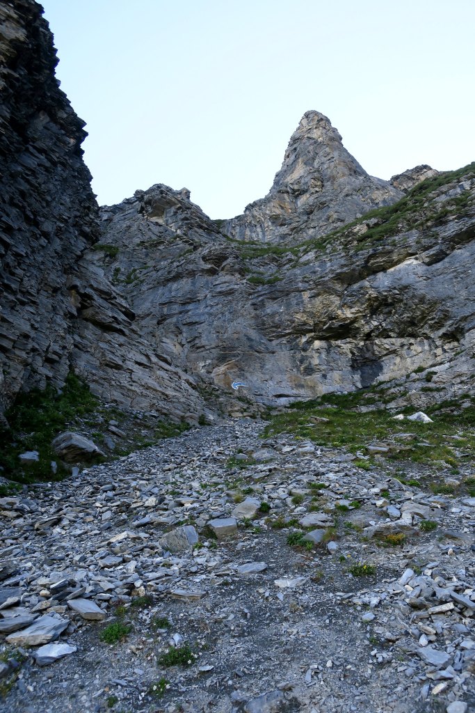
Views on the way to Rottalhütte
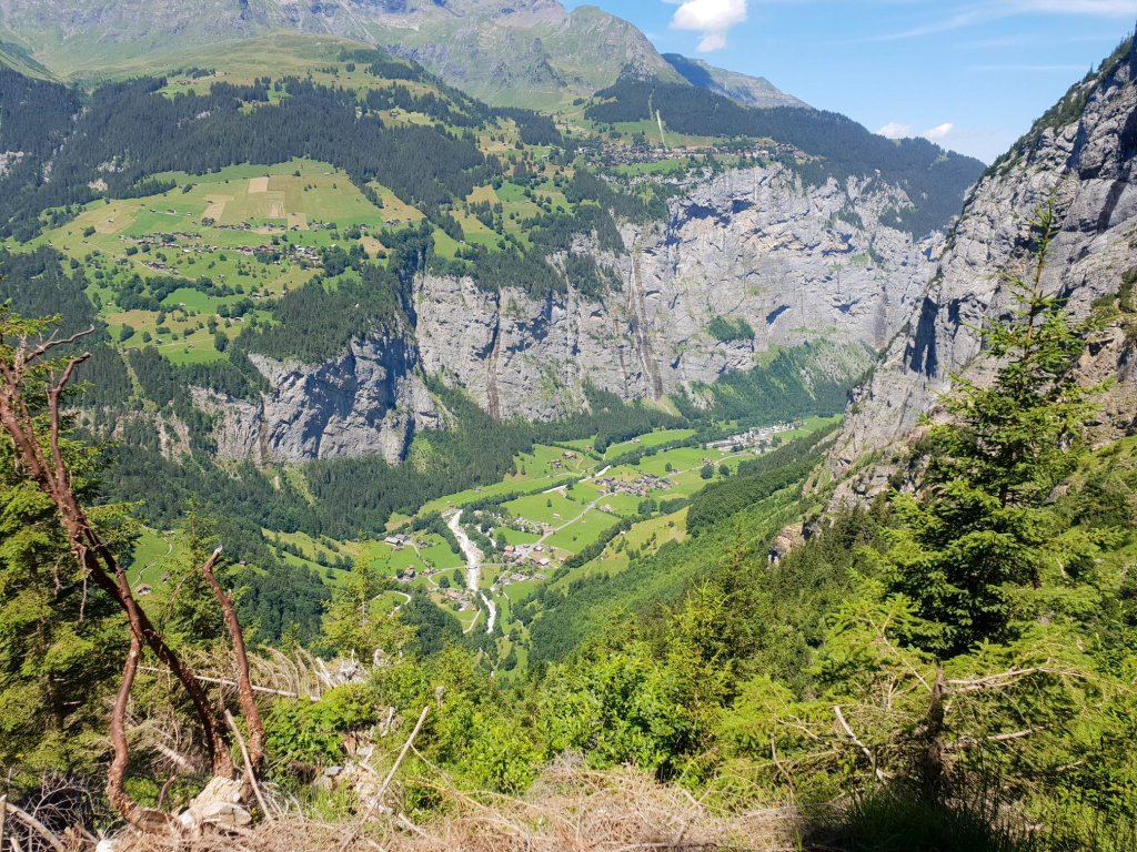
It was clear on the way up that the views were going to be spectacular.


The four peaks which line the southern part of the Jungfrau Region, Mittaghorn, Grosshorn, Breithorn, and Tschingelhorn all were coming into perfect view. Across the valley, Ellstabhorn and its high meadows called Busen, an area still on my to-do list. And further back across the valley, the triangular peak of the Schilthorn poked above the emerald horizon.


On this side of the valley, the Steufesteinhütte and the long Rottalbach waterfall and mountain stream gave me something to explore on the return trip.
I passed one hiker who was descending, just after the intersection where the route to the Silberhornhütte branched off. Otherwise, I was completely alone up to this point.

Even at 2100m elevation, the Rottalhütte cannot be seen from the trail. Wherever this trail is headed lay beyond a craggy wall looming in the shadows above me with no obvious trail to traverse it. I could see that there was a split in the cliff face. My Scaredy Bear radar was at this point booting up.

As I got closer, the trail became a sea of loose shale, like walking over a bed of razorblades. I cursed myself for forgetting my hiking poles. At 2200m I reached this split. Oddly my first impression was This is it? But then my Scaredy Bear radar finished booting up…
The name of the formation is the Bärenflue. I have read that it is anywhere from 50-100m high. Distances and dimensions are so hard to judge when you are surrounded by such immensity in nature. And photos surely do no justice. Even though I was there, I cannot confirm to the reader how high. I suppose to the experienced, it is closer to 50m and to the less-experienced it is more like 100m. The best way to describe it is a steep stairway of sharp loose stones with an even looser steel cable for assistance.
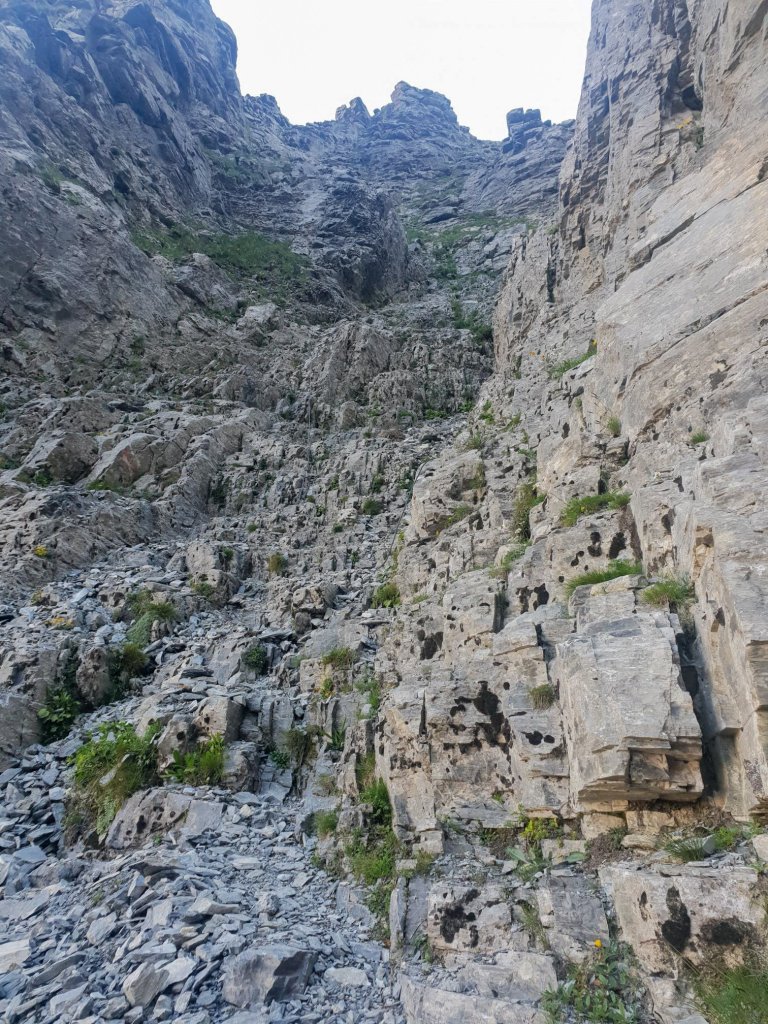
I scanned the stones for the easiest route up and tentatively found my first foothold and started my ascent. Every other step was met with the disintegration of my foothold sending a small avalanche of razor-like stones downwards. This is definitely a climb that should only be done one person at a time. With each footstep, my heart pounded faster, and I began to realize that the angle of the slope was uneven leaving me incapable of seeing where I could step up or down. It was becoming a matter of hunting. The amount of time that this climb was going to take created it’s own avalanche in my mind. The grip of the steel cable was slick and didn’t feel secure. I looked backwards and down trying to see how far I had come, sweat already pouring down my face and shirt. Maybe I had reached 5 meters, maybe 10. But the ground was not a flat surface. Where the climb starts is already at the top of a steep incline. The entire valley below was open in front of me. The profile of the adjacent cliff against this backdrop contributed to enhancing the sensation of depth and exposure. I probably broke every rule of climbing. Don’t look down. All of my resolve collapsed like the stones I was kicking as I started to panic in search of a step down. At this point, caring about what I was going to write in my blog or how I was going to explain this to people was the least of my worries. I just had to get off that flue. I resisted the urge to go too fast knowing that I was essentially climbing over knives. I eventually reached the bottom and sat down at the base of the cliff breathing a long sigh of relief.

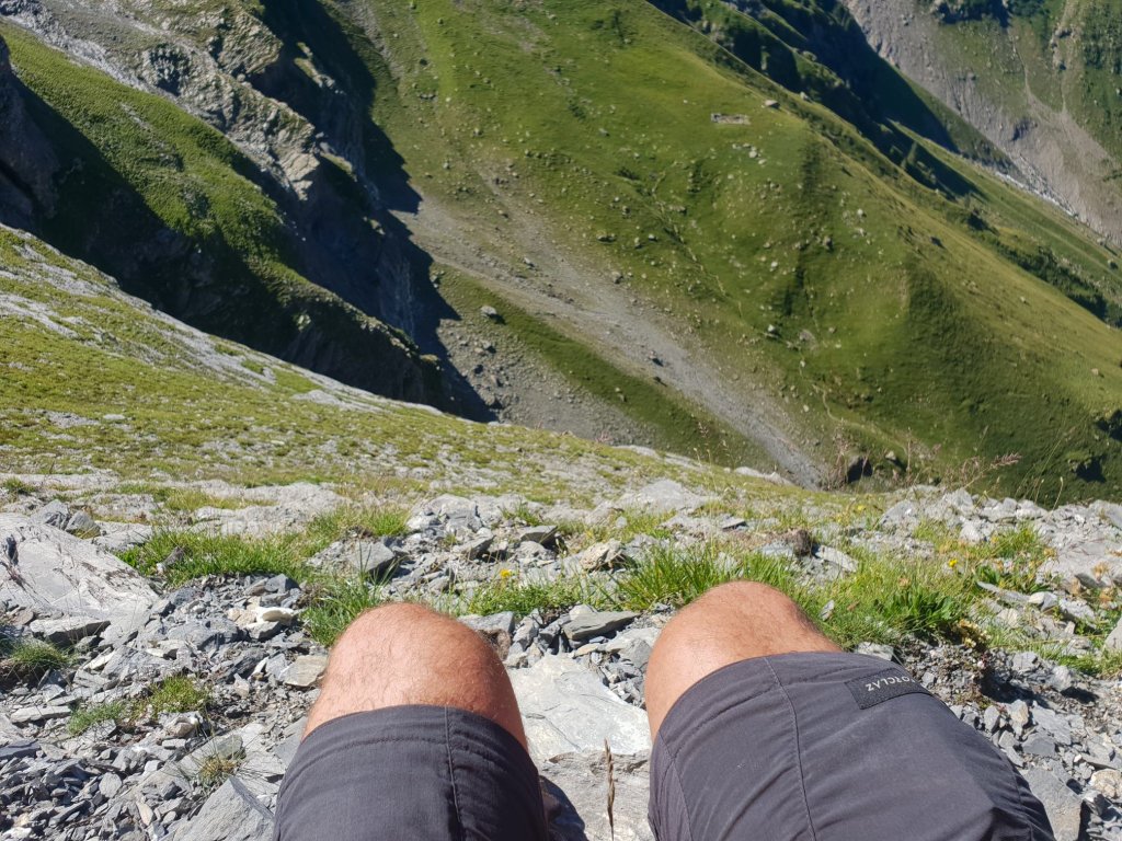
As I regained my composure and started to come to terms with another Scaredy Bear moment, before the feeling of total loss overcame me, I looked out over the vast scenery which lay at my feet. The base of the cliff was like the top row of bleachers overlooking a stadium like I’ve never seen before. The scenery was massive. The closest experience I could compare this to was reaching my Scaredy Bear moment during the Schreckhornhütte hike. But this surpassed that one. I realized that what I was looking at was by far worth the effort to get here. This was no participation trophy. And I had it all to myself.
I decided that to make something more purposeful of the hike, I would head back down to the Y in the trail and see how far I could get on the Silberhornhütte trail. I was pretty convinced at this point that my fate would be the same. But at least I could recount both experiences in one effort.

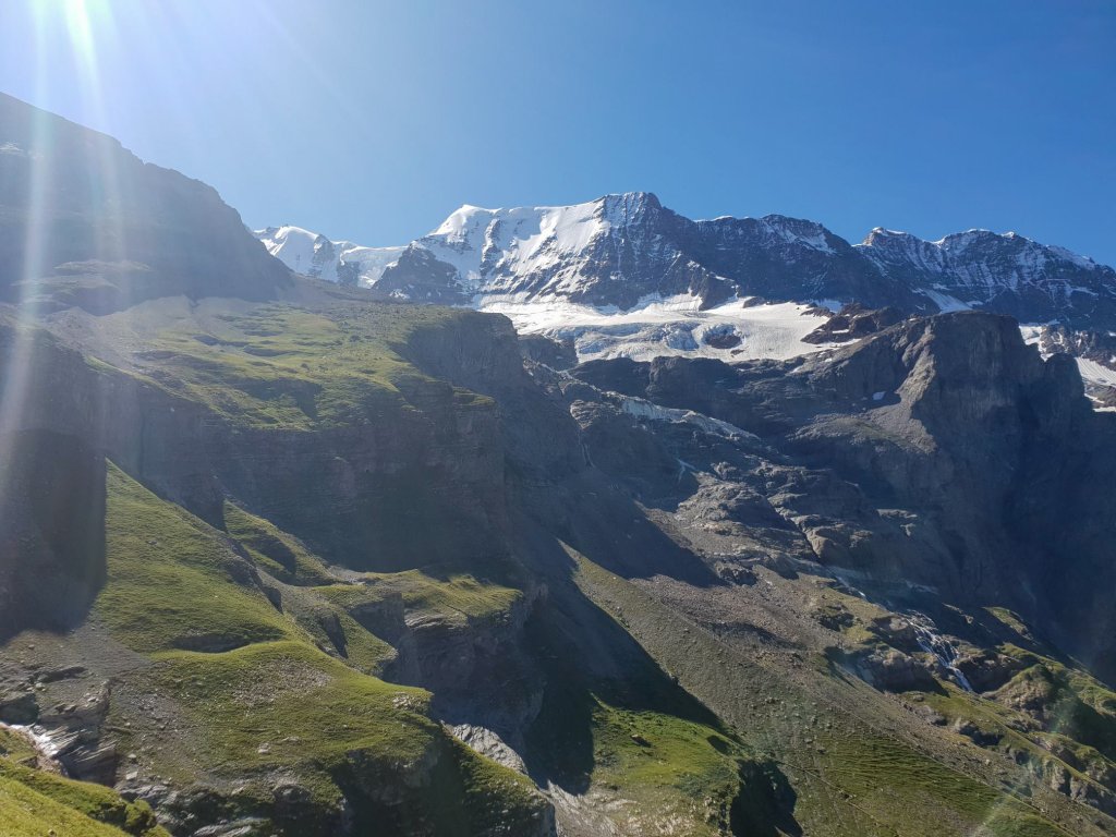
Views on the way to Silberhornhütte
From the Y, I managed to get further up that trail than I had on the Rottalhütte. The topography of the Silberhornhütte trail is impressive. It rides along a steep slope and is completely exposed.

After getting past a grassy section, the slope is almost entirely consisting of stones. I could see the trail markings leading across and up in the distance towards a chimney section. I would later come to realize that the chimney section requires a vertical climb with the aid of chains. I was told it was much more dangerous than the Bärenflue and probably one reason you don’t find the trail marked on some maps or signposts pointing to it.


At that point, I decided I had had enough of testing my fears and I decided to stop there and again partake in the spectacular views of this natural arena.
On the way down, I took a detour to visit the Steufesteinhütte and Rottalbach. The hut is not intended as a respite for hikers. It was populated by goats and one small cow. The animals were particularly curious of my visit and in the case of goats, you can never really tell if their approach is friendly or with the intent of driving their horns into your stomach. But an amusing staredown with the ring leader brought some levity to a hike that was both mindbogglingly beautiful and humbling at the same time.


Hike Details
| Starting Point | Stechelberg |
| Ending Point | Stechelberg |
| Distance | 12.9 km |
| Moving / Total Time | 4 hours 29 mins / 8 hours 0 mins |
| Ascent | 1360m |
| Eating Place | Hotel Restaurant Stechelberg |
| Scaredy Bear Features | Bärenflue steep climb with steel cable (Rottalhütte) Treacherous exposed trail and chimney climb with chains (Silberhornhütte) |

Final Words
On the way down from the Bärenflue, I passed a woman, probably late-50’s, carrying an expensive camera and snapping shots of some grazing goats. She was dressed in drab green and looked like a nature photographer for National Geographic. I knew without a doubt she didn’t just come up here to shoot pictures of goats. She was doing the flue and on her way to the hidden glory of the Rottalhütte. On the way down from the Silberhornhütte trail, I met a local guy who was taking his son, about 12-13 years old, up to the Silberhornhütte to spend the night for the first time. He himself has been there many times.
As I descended, my mind was a whirlwind of thoughts, both proud and self-effacing. Thoughtful and reflective yet disappointed. Appreciative but with a lingering sense of unfulfilment. I know this is all in my mind. Perhaps having a guide who can talk me through the rough spots or keep my attention focused would help. There is no doubt that the hike even in this abbreviated format had scenery which will fill my soul with great joy and with great memories for years to come. A couple days later, two Slovenian hikers approached me in the morning to ask me for a good place to hike. I didn’t hesitate. I pointed up towards this high valley and said there. I never saw them again and I don’t know if they took my advice or not. I explained the challenges. But I like to think that those guys are somewhere bragging about the same otherworldly views that I am sharing here. My Scaredy Bear List may have two more entries but even without reaching the huts, this hike is no walk in the park and the rewards are indescribable. Though, I hope I have done them justice anyway. Thank you humbly for reading.


Looks like some challenging hiking – well deserved beers!
LikeLiked by 1 person
Thanks, my brother… wish the beers were better than the Swiss ones 😂
LikeLiked by 1 person
i had the same experience on the way to silberhornhutte. I just got so scared and ran out of courage and had to turn back. It still annoys me years later (as evidenced by this comment!). I enjoyed reading your post though.
LikeLiked by 1 person
Thank you for reading, Zurigo. Good to know I am not the only one who has these moments
LikeLike