
Chalk up another casualty to my fear of heights.
Anyone who stops by my blog for at least long enough for it to register as a visit in my Stats knows that I love hiking the Alps. But damn… once in a while I hit a wall where that pathway in the brain leading to the brain cells containing my fear of heights fires on all cylinders. The title of this post was supposed to be Glecksteinhütte – Chrinnenhorn, said with chest pushed out and a loud baritone voice, not the rather mundane, feeble, and ill-advised knockoff on Dr. Strangelove.
But *voice cracks* I am here to present what actually turned out to be a pleasant hike. Not a great hike. But a pleasant one. And actually I am being facetious. Every hike of every skill level is an amazing one in the Jungfrau Region. But the one I am about to present was a consolation prize for what was supposed to be an epic hike of epic proportions…*clears throat*, not only to Glecksteinhütte but beyond that to Chrinnenhorn.
The Original Idea
Here, ladies and gentlemen, was the epic hike. This hike starts at Hotel Wetterhorn and climbs to the Glecksteinhütte (1) and ends at the Chrinnenhorn (2). Here is the Glecksteinhütte & Chrinnenhorn link for anyone interested.

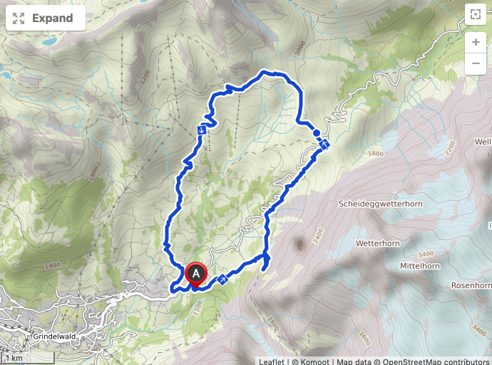
Here is as far as I got

If you compare the two, you can see I didn’t get very far up the trail towards Glecksteinhütte. Notice the jumpy GPS where I doubled back.
The Abbreviated Hike in the Direction of Glecksteinhütte
The cool part of this hike was crossing the Obergletscher glacier. Woo hoo.

The hike then continues innocently enough until you notice that the path is not only getting more narrow but starting to feel like the Death Road in Bolivia. Sheer drop on one side and a steep mountain-side on the other. This was the last picture I took. I did actually make it further past the vegetation, where the exposed rock wall, narrow path, and steep drop finally did in any will I had to grab my camera.

So with my tail between my legs I climbed down, crossed back over the glacier, pulled my Komoot app out and laid out a plan for a different hike.
The Pleasant Route
- Starting Point: Hotel Wetterhorn
- Ending Point: Hotel Wetterhorn
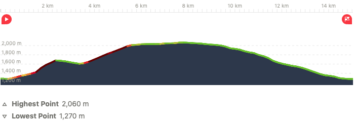
- Distance: 15.0 km
- Moving Time: 4 hours 8 minutes
- Eating Place: Hotel Grosse Scheidegg, Hotel Wetterhorn
- Komoot Link: Hike Link
Photographic Journey
The hike from the Glecksteinhütte trailhead to Grosse Scheidegg is steeper and more challenging than I had anticipated. It was not the most beautiful part of the hike, partly due to the visibility.

Grosse Scheidegg was a fortunate presence when the rains started to come. Ducking inside for a hot bowl of goulash was not a bad deal.

After Grosse Scheidegg, the path is known as the Romantikweg, probably because it is a very flat, easy path with normally glorious views over Grindelwald.
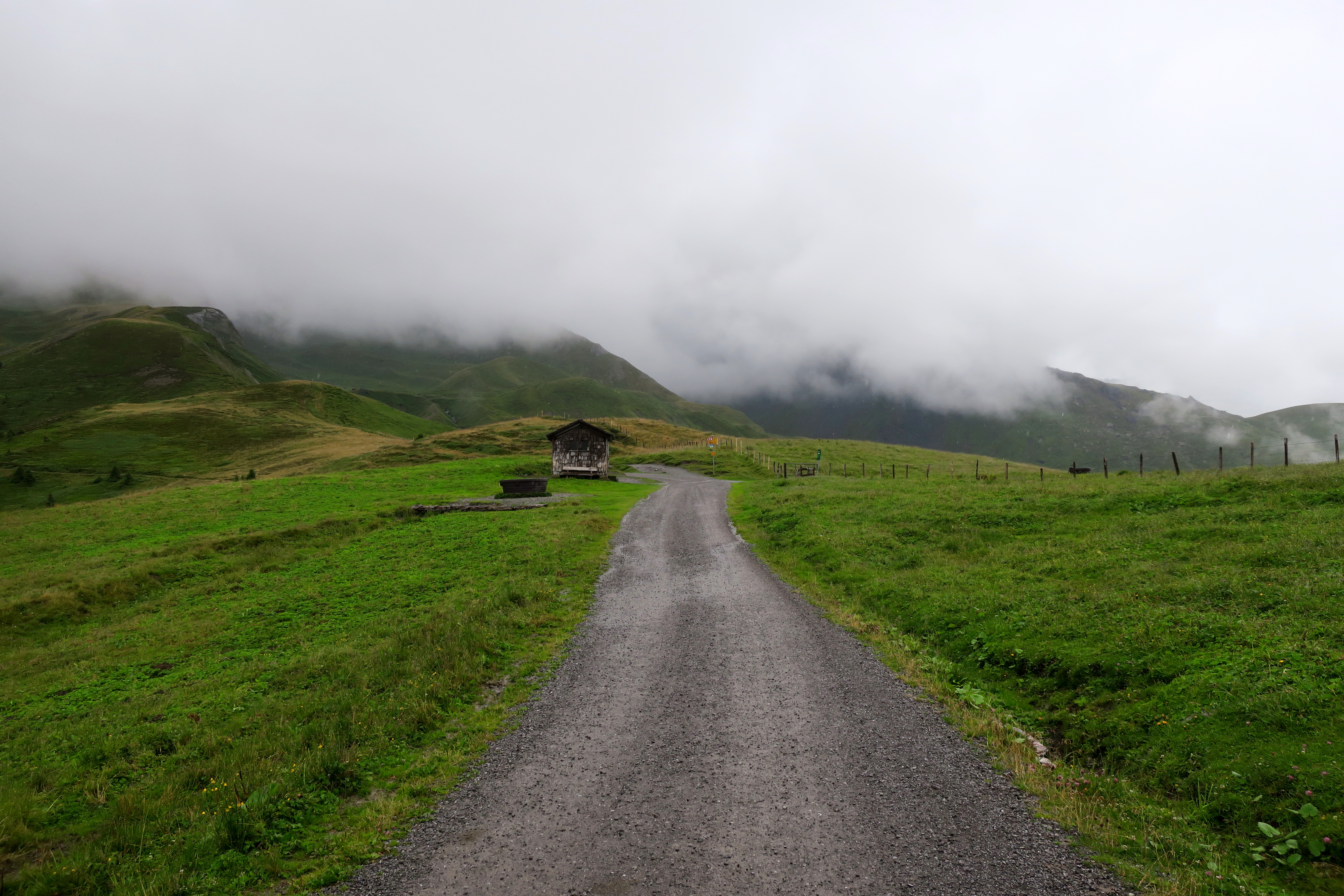
It is definitely a gentle trail and the views are pretty good.

The descent more or less follows a road down thru several small clusters of wooden chalets, sometimes difficult to tell if they are farm storages and shelters or actually places to live.


Eventually you find yourself back on the doorstep of the Hotel Wetterhorn where you can catch a bus back to Grindelwald.
What of Glecksteinhütte and Chrinnenhorn
During the descent, I caught a good view of the path leading from the Obergletscher to Glecksteinhütte. As I was admiring and studying the path, a mountain biker approached me. He was a local and I decided to ask him about the path to the Glecksteinhütte. “It’s the whole way like that!” he exclaimed when I mentioned my not-so-brave brush with death. He added, “I could never do that by myself, but my wife has no problems with that. She talked me through it. If you have a good guide, you will have no problem.“

I regret not asking about Chrinnenhorn. It wasn’t until later in the week that I found a good view of the whole route.

So I am adding it to my scaredy-cat list which currently includes finishing the Schreckhornhütte. Where is my brave hiking partner of a daughter when I need her? Probably somewhere thinking of how she will peer pressure me up that path in the future. But it really begs the question… what happens when there are people coming the other way? Well, perhaps I will find out one day. In the meantime, I relish in the pleasant but not epic memories of this day. And any pleasant day in the Swiss Alps is an epic day in life.
UPDATE (25/3/2020)
Thanks to one of my commenters for pointing out several mistakes in my photograph above where I point to three locations. I therefore offer his corrections and apologize to any readers who have suffered from my error.
- I point to a small patch of ice which I refer to as Obergletscher, but that is not the actual Obergletscher. It is just that, a patch of ice.
- Where I point to Glecksteinhütte is actually an unused tramway station.
- Where I point to Chrinnenhorn is actually the Glecksteinhütte. Therefore, Chrinnenhorn is not visible in the picture!
Featured Beer

| Beer | Feldschlösschen Dunkel |
| Brewery | Feldschlösschen |
| City/Country | Rheinfelden, Switzerland |

Discretion is the better part of valour. No point starting out on something and then getting crag fast. Think I’d have made the same decision.
LikeLiked by 3 people
I should have used the word “discretion”. Thanks for relating 😁
LikeLiked by 1 person
OH HELLS NO. You got way farther than I would have — so tip of the hat to you for even venturing onto that trail. It still looks like a wonderful walk, even if you didn’t need to deploy any carabiners.
LikeLiked by 3 people
I sympathise I too have a fear of heights. Beautiful photos!
LikeLiked by 2 people
Done a little bit in the Alps but my courage would have certainly given out on that one. The glacier up close must have been fantastic.
LikeLiked by 2 people
Hi, I hiked to the Glecksteinhütte this summer to spend to nights there. I just want to mention that your last pic in your story the marking points are wrong. Sorry to say 😦 The place where you point Obergletscher is just a snowy patch which stays there all year round because it’s on the north side of the mountain. The Glecksteinhütte mark is the is the former upper aerial tramway station (one of the world’s first passenger carrying aerial tramway) which was only in operation until the beginning of World War I. And Chrinnenhorn is the actual Glecksteinhütte! The glacier on the right side of the Glecksteinhütte is the Obergletscher.
LikeLike
I am just reading this. My apologies for getting back to you so late. That explains a lot of my confusion that I was having with my Komoot map. That tramway was the problem. Now it makes perfect sense 🙂 I will correct it.
LikeLike
Probably the wise move in that weather anyway. Looks like weather better spent in the brewery.
LikeLiked by 1 person